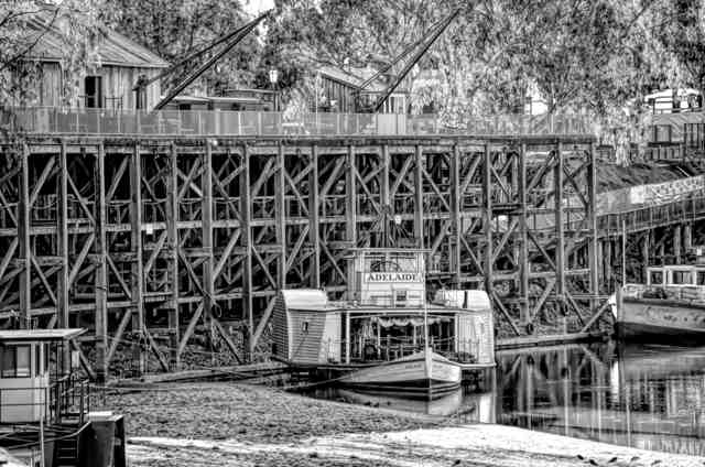
In Chris Fithall’s 2019 photograph, the paddle steamer Adelaide sits below a wall of timber framing. Cranes stand on the deck high above it. The image is black and white, but it is not a photograph from the river-trade era. It shows a later version of a structure built to solve an old problem: the river would not stay at one height.
Echuca’s wharf was designed with three docking levels. The arrangement let boats meet the structure at different river stages rather than requiring one permanently convenient waterline. Campaspe Port Enterprise’s history identifies that purpose in its account of construction beginning in the 1860s. [1]
Where is this place?
Echuca Wharf, Murray Esplanade — geographic context, not navigation, flood or current visitor-access guidance. This map locates the town or region, not a verified exact historic event site.
The height can look theatrical from the water. It was part of the work.
Two transport systems met at different levels
The wharf’s job was not simply to provide somewhere to tie up. Echuca connected river traffic with the railway to Melbourne. Wool, grain, timber and other cargo could change transport here, linking inland producers with coastal markets. The federal heritage account treats the wharf and railway together when explaining the port’s importance. [2]
The Australian Heritage Council’s assessment describes cranes, wool-handling equipment and stores on the upper level, with the tall wharf accommodating substantial changes in river height. Its historical account also makes clear that river trade depended on variable water levels: drought restricted navigation elsewhere in the river system. A wharf designed for changing water was not a promise that every river journey would remain possible. [3]
Read this way, the timber framework is more than a picturesque backdrop for steamers. It marks a practical negotiation between a fixed land connection and boats carried at the river’s level. The two photographs show that vertical relationship; they do not measure the river or establish a safe operating height.
Length was another matter
As trade grew, the wharf extended along the bank. The federal account records a maximum length of 332 metres, reached after successive nineteenth-century additions. During the Second World War, Victorian Railways dismantled much of it to supply firewood to Melbourne. The remaining section described in that account measures 75.5 metres. [2]
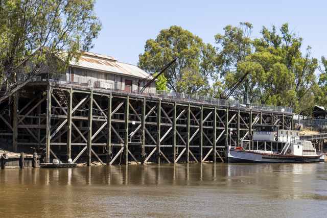
The tall structure in the photographs is therefore not the whole former port stretched into view. Much of its horizontal reach disappeared, while its vertical arrangement remained legible.
Nor is every surviving-looking piece untouched nineteenth-century fabric. The heritage assessment records replacement decking, reconstructed walkways and renewed structural timbers. It also identifies a relocated cargo shed and replacement or relocated cranes. Those distinctions prevent the later port display from being mistaken for an intact scene left exactly where the last commercial cargo landed. [3]
A working idea, a different audience
Campaspe Port Enterprise dates government-supported restoration work to 1973 and the port’s opening as a tourist attraction to 1974. A new audience was being invited to understand what the wharf had done. [1]
That interpretive work continued. In December 2013, ABC reported the completion of a port redevelopment that included red-gum walkways and a discovery centre. This was another stage in presenting the place, not the date when all of its history began—or proof that every timber visible today belongs to that project. [4]
The later photographs retain an especially useful clue. Before looking at the cranes or naming the boats, notice the space between the water and the upper deck. Echuca’s wharf was built around a difference in levels. Its height still makes that problem visible.